Free trial Sign in
  1. Recording a House History – how to get started
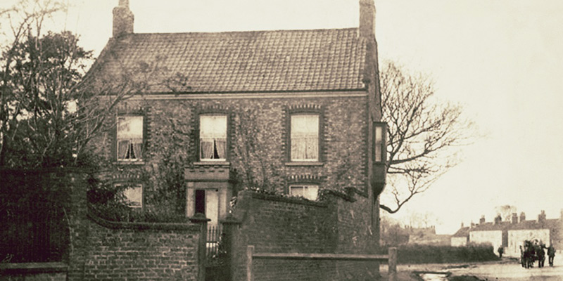
    The Mount to Betsy Refern, Rillington, North Yorkshire

    Hands up if you’re a local or family historian who’s been captivated by the BBC2 programme ‘A House Through Time?’ Yes as we suspected, a sea of hands are creating many waves and ripples! As the backstories are revealed, we learnt in this third series who lived, loved and died in one property in Bristol. Using an eclectic mix of records and sources, the viewer is guided through an historical timeline of events from when the house was first constructed, through to present day. We also witnessed the impact of national and local events on the people who lived there.

    As you start to trace the history of a property and its occupants, we know it can be time-consuming collating the information from a variety of sources. So, if you’ve been inspired to now start your own house history research, then allow Name & Place to keep your work both secure and manageable. As your research grows, our unique software designed as a 3-dimensional layered database, enables you to take slices through your data at any moment in time during the history of the house in order to produce the outcomes you need. Think of a Rubik’s cube which also layers diagonally and it will give you a clue as to the benefits you can achieve. Once your information has been entered, the options as to where you subsequently retrieve, display and share it have few limits.

    Sample house deeds

    Sample house deeds

    After identifying your chosen place be it a dwelling or building, you can now start to gather your sources, maps and old postcards. Successfully locating the precise house and plot of land on a map can be the first challenge as many of the older properties in a rural environment were not allocated numbers until the twentieth century. Once secured, using the Name & Place database, you can start working through this suggested checklist:

    • Add a NEW PLACE and work backwards from what you know. If the deeds are not in your possession then contact the Land Registry to consider your options. https://www.gov.uk/government/organisations/land-registry
    • Layer on an entry from the 1939 Register for a full household transcript and use the 1945 Farm Survey if relevant to take notes of the rooms and their contents. Don’t forget the garden.
    • Previous census imports 1841-1911 may have picked up your place so you can now review the enumerator’s route against a tithe or OS map.
    • Check the 1910 Valuation Office Survey for land use, value, ownership and description.
    • Electoral Rolls and Poll Books may contain names, addresses and qualifications for voting. Always worth a look.
    • Don’t forget Trade Directories can also hold evidence of names and occupations.
    • Rate Books were local taxes for the upkeep of local services so use them. You may discover the names of previous owners of a property.
    • Add sources such as deeds and wills to document the changes in land ownership.
    • Click on MEDIA to download your selected images such as old postcards, present-day views and old photographs.  Once imported you can readily compare, contrast and document any visual changes in both the appearance and structure. This is also where you can add images of tithe, Ordnance Survey and footpath maps.
    • Is the property is a listed building? Check https://historicengland.org.uk/listing/the-list/ and if so, try and establish why and are the reasons still relevant today.
    • People make a house a home so introduce the characters who lived there over time.

    Maps, showing your house’s position in a wider context, can be easily added to your research project.

    Et voila! A house history timeline at your fingertips.
  2. Mapping it out

    Records can describe how farms and villages have developed into industrial towns and cities, yet all you can witness today are bricks and concrete. A map, however, provides a visual snapshot frozen in time and can better demonstrate the social and economic layout of a community’s hidden past. As importantly, any accompanying schedules, are an indispensable way of identifying what has gone before

    Here are a few examples for you to discover a community footprint for your project:

    • Enclosure maps and awards – these maps capture changes in the landscape particularly where stripe of agricultural land develop into larger enclosed fields. The award can identify ownership of land and thus providing valuable family information.
    • Tithe map and apportionments – colourful large-scale tithe maps show each building, church, pathway and stream and more. The schedule of apportionment gives details of the owner and occupier along with a description of the plot plus the amount of rent-charge. The plot numbers cross reference the numbering of plots on both the map and the apportionment schedule.
    • Estate maps and rental schedules– commissioned by landowners to capture the extent of their estate, these wonderful maps contain details of houses, fields and woodlands, often with the names of adjacent landowners. If you’re lucky there may be an accompanying rental schedule giving names of tenants and their land and cottage plus the amount of rent.
    • Ordnance survey – historical ordnance survey maps are incredibly useful and suit both rural and urban areas. They are ideal in tracking demolition and development throughout the centuries.
    • Fire Insurance Plans and Registers – these town plans were commissioned to identify potential liability in the event of a fire and were updated every few years. Where accompanied by fire registers, personal information can be obtained about the policy holder: name, address and occupation together with details of the construction and value of the property. These are held by the Guildhall Library and the British Library.
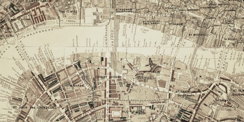
    • Charles Booth’s Poverty Maps and notebooks – In essence these social class maps are specific for East End communities in London. Together with data collected from police officers on their London beats, Stepney Union casebooks and Jewish notebooks offer a rich insight to life in the 1880s and 1890s. Our image for this blog has been taken from https://booth.lse.ac.uk
    • Valuation Office Survey, Valuation and Field Books – these records relate to a survey carried out between 1910-1915 which are useful for identifying property ownership, value, use, tenancy and date of erection by consulting the plan and fields books at the National Archives, Kew (TNA).
    • The National Farm Survey and Primary Farm Records – carried out between 1941-1943, these records give more recent information on farmland, farmers and farm workers and are held at TNA. Useful to chat with locals who have living farming memories.
    • Alan Godfrey Maps – reprints of old ordnance survey maps comprising more than 3,000 titles so far. Accompanied by a description of the area or a selection from the trade directory. http://www.alangodfreymaps.co.uk

    Maps should be used in conjunction with other maps and records such as census, GRO certificates, wills, trade directories, old postcards and title deeds to establish a location and identify family relationships. Discover online maps for convenience, however nothing beats the scale and feel of old hand-drawn cartography. Visit the National Archives, Local Archives, Diocesan Archives and Libraries to find out for yourself.